
Tropical cyclones are classified in accordance with the World Meteorological Organization’s recommendation by the maximum sustained wind speeds near the centre. In Hong Kong, the classification is defined in terms of wind speeds averaged over a period of 10 minutes as follows :
|
Tropical Cyclone Classification |
|
Maximum 10-minute mean wind near the centre |
|
Tropical Depression |
up to 62 km/h |
|
|
Tropical Storm |
63 to 87 km/h |
|
|
Severe Tropical Storm |
88 to 117 km/h |
|
|
Typhoon |
118 to 149 km/h |
|
|
Severe Typhoon |
150 to 184 km/h |
|
|
Super Typhoon |
185 km/h or above |
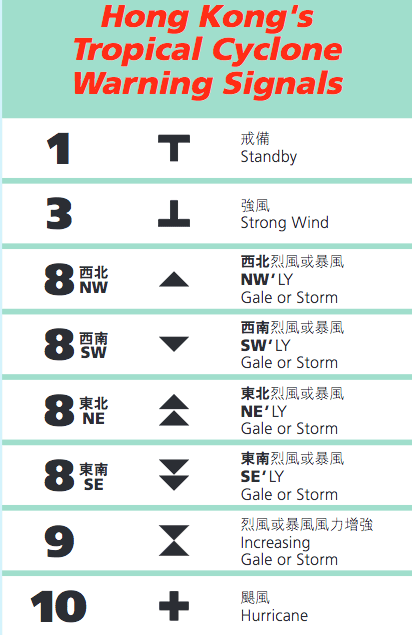
What do the HK Observatory Signals Mean?
1 – A tropical cyclone is centred within about 800 km of Hong Kong and may affect the territory.
3 – Strong wind is expected or blowing generally in Hong Kong near sea level, with a sustained speed of 41-62km/h, and gusts which may exceed 110km/h, and the wind condition is expected to persist.
8 – Gale or storm force wind is expected or blowing generally in Hong Kong near sea level, with a sustained wind speed of 63-117km/h from the quarter indicated and gusts which may exceed 180 km/h, and the wind condition is expected to persist.
9 – Gale or storm force wind is increasing or expected to increase significantly in strength.
10 – Hurricane force wind is expected or blowing with sustained speed reaching upwards from 118 km/h and gusts that may exceed 220 km/h.
Here’s a list of storms that have ‘hit’ Hong Kong since 2012
2012:
Doksuri (No.8)
Kai Tak (No.8)
Vicente (No.10)
2013:
Utor (No.8)
Usagi (No.8)
2014:
Kalmaegi (No. 8)
2015:
Linfa (No. 8)
2016:
Nida (No.8)
For the latest HK Weather news check the HK Observatory’s website