1.2 Billion Pixel Panorama of Mars

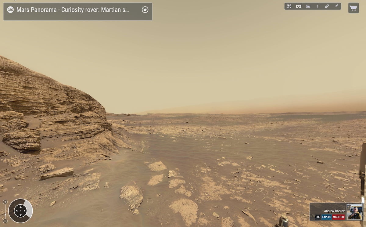
NASA’s Curiosity rover captured this high-resolution panorama of the Martian surface between Sol 3057 (12 March) and Sol 3062 (17 March 2019).

http://www.360cities.net/image/mars-gigapixel-panorama-curiosity-solar-day-3060#342.00,-2.90,35.5

The version without the rover contains 136 images from 34-millimeter Mast Camera; a version with the rover contains 260 images from 100-millimeter telephoto Mast Camera. Both versions are composed of more than 396 images that were carefully stitched.

Scott Guzewich an Atmospheric Scientist at NASA’s Goddard Space Flight Center commented about the image “Humans minds don’t easily comprehend the vast eons of time that separate us from the places we explore in space with robots like Curiosity. Our minds are designed to think in terms of hours, days, seasons, and years, extending up to a duration of our lifetime and perhaps those a few generations before us.

When we explore Mars, we’re roving over rocks that formed billions of years ago and many of which have been exposed on the surface for at least tens or hundreds of millions of years. It’s a gap of time that we can understand numerically, but there’s no way to have an innate feel for the incredible ancientness of the planet and Gale Crater.”

More panoramas of Mars by Curiosity rover: http://www.360cities.net/sets/curiosity-mars

Mars Upclose…

The European Space Agency (ESA) has released a trove of almost 100,000 images of the red planet. Captured by the Visual Monitoring Camera (VMC) onboard the Mars Express orbiter the images were taken between 2007 and 2020.

There are also images of the release of the Beagle 2 lander in 2003. While the images have been released for scientific study, the public can browse them as well.

The image archive has hundreds of photos of Mars taken from orbit, showing the huge range of geographical features and diverse formations found on the planet. In the collage of images here, you can see everything from dust and water over the north pole (first image, top row), to an unusual cloud formation called the Arsia Mons Elongated Cloud (second image, top row), to a double cyclone raging over the planet’s north pole (fourth image, top row), to the enormous structures of the Tharsis Volcanoes and Olympus Mons (third image, second row), to the Valles Marineris canyon system (third image, third row).

The VMC was originally intended to observe the release of the British Beagle 2 lander, transported to Mars by ESA in 2003. However the lander disappeared after its deployment and its exact fate remained unknown until 2015, when NASA’s Mars Reconnaissance Orbiter’s HiRISE camera captured its location. From the images, engineers could see that Beagle 2 landed safely but failed to deploy two of its solar panels, meaning it was not able to communicate with Earth.

Despite the failure of the Beagle 2 mission, the VMC was repurposed in 2007, and has been used to capture images for various scientific papers about Mars.

Note that the images have been adjusted for sensor ‘noise’ and variations in pixel sensitivity and the results are stunning.

Image: ESA Planetary Science Archive